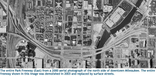
Milwaukee’s Park East Freeway Removal
In 1971, the first section of Milwaukee’s Park East Freeway, connecting I-43 to downtown, was complete, and a block-wide swath of houses and businesses had been cleared to make way for continuation of the freeway to the lakefront. But neighborhood and environmental activists created sufficient opposition to stop construction of the extension, which would have bisected and blighted a major city park, cutting it off from Lake Michigan.
Thirty years later Milwaukee went a giant step further– they demolished the existing stretch of Park East Freeway, removing a dividing wall that cut through the city’s downtown, opening up 24 acres to development, and increasing the development value of the land in the shadow of the former elevated highway.
Why did Milwaukee tear down a highway?
One of the activists who opposed the freeway plan in the 70’s was John Norquist, a lathe operator a community organizer, who later became a state legislator and then mayor in 1988. As mayor, Norquist saw the benefits that flowed when the State released the vacant land that had been cleared for the unbuilt section of the Park East Freeway. Sold off for redevelopment, that acreage became the East Pointe neighborhood, a mix-use area of townhouses, condos, restaurants, shops, even a supermarket with pedestrian-friendly entrance on one side and parking lot on the other. The Urban Land Institute, presenting the project an Award for Excellence, noted: “East Pointe represents the culmination of a two-decade struggle to evolve from a proposed freeway that would have divided and further damaged a neighborhood into the creation of one of the country’s most successful examples of urban housing and neighborhood revitalization.”
Norquist also paid attention when the students of Peter Park, an adjunct professor at the University of Wisconsin – Milwaukee School of Architecture and Urban Planning explored removal of the freeway in design studio projects. Park was invited to serve as the City’s Planning Director, and worked with Norquist in heightening the importance of comprehensive planning and design standards.
Demolished in 2003 and replaced by a six-lane street level boulevard, the Park East freeway removal has been deemed a success. With traffic eased by a restored city street grid, congestion predictions never played out. And the economic development hoped for has begun to materialize. By 2007 projects totaling over $300 million in investment had been completed, approved or proposed.

While there are differences between the Park East and I-81 viaducts, what can Syracuse learn from the Milwaukee experience?
Milwaukee, like Syracuse, is a city with a rustbelt economy looking to renew itself. The freeway created negative space in a downtown where there was a potential for local growth and neighborhood connection. When the freeway came down, it was replaced by three linked neighborhoods. Ugly surface level parking lots began to disappear and housing, commercial and institutional projects took over. This new development was piggybacking off of an earlier development that had already brought suburbanites back into the city. East Pointe was already in place on the site of the formerly planned freeway, and spurred new growth, bringing urban vibrancy to places where people hadn’t wanted to walk before.
To have a vital city center, people have to enjoy living and working there. But what, besides the promise of a more attractive cityscape and enhanced economic development, is driving the movement to take down elevated freeways across America? Money is one reason. Freeway bridges will need major, costly rebuilding within the next decade (as did Milwaukee’s elevated freeway before it was taken down.) If the Milwaukee viaduct had been replaced rather than removed, the cost would have been $100 million. Instead only $25 million was spent in demolition and at-grade street improvements. Rebuilding the elevated roadway would also probably have kept Milwaukee in a stranglehold of construction for far longer.

Did the Park East freeway removals cause traffic nightmares? No, the freeway had complicated the traffic patterns, concentrating all traffic on just three streets and causing congestion. Once the freeway came down and the streets were restored into a grid, traffic dispersed on two dozen streets and traffic flow improved.
Could removing the I-81 viaduct work the same way in downtown Syracuse? It’s impossible to be sure. While the I-81 viaduct is a “hybrid” serving both interstate traffic and local commuters, Milwaukee’s Park East was a “spur,” a short stretch connecting another highway to downtown. In 1999, it carried 54,000 vehicles per day on weekdays.
Current estimates are that approximately 75,000 – 100,000 vehicles travel on the I-81 viaduct each day. An estimated 60% of those are local trips, close to the number of Park East vehicle trips. Enhancements to the Almond Street boulevard, as well as to the street grid along the corridor would be necessary. Studies of some changes, such as conversion of one-way to two-way streets, and use of roundabouts at intersections, are already underway. Relocation of I-81 through-traffic to I-481, and reconstruction of the merges of those routes would also have to be studied and planned.
For many, the verdict is in: freeways are not good for cities. They drove businesses and people out. With freeways like I-81 cutting their most productive neighborhoods off from each other and facilitating suburban development, or “urban sprawl,” many cities have lost out. And in an age of global warming, transportation planners are looking toward balanced transportation systems that accommodate transit, bicyclists, and pedestrians as well as cars.
Pingback: NYCO’s Blog » Other people's blogs
i love the comparison of highways between milwaukee and syracuse, but i’d be a little worried about demolishing 81 and trying to bring the suburbs into the city. and by that i mean bringing in typologically suburban buildings and putting them in the center of downtown. it almost becomes (and looks) fairly silly and inappropriate. just by looking at that one picture of the east point commons, you are already loosing a lot of public space that normally gets overlooked (and almost thrown away) in a suburban setting: vertically (by only bringing in apartment dwellers and no commercial aspects) and horizontally (by bringing in greenspace but having it under-utilized by sectioning or fencing-off an area for a select small group of people).
if there’s going to be any greenery or park areas constructed downtown after 81 is demolished, it should be open to the public. mainly because there isn’t nearly enough public park space in downtown. i suppose that’s one of the reasons why i’m hoping that some form of urban park can be built when/if 81 gets demolished… because there is just so few (if at all?) real parks or greenery downtown.
instead of townhouses or sectioned off condos, i’d much rather see 3-story mixed use buildings (with office, commercial, and residential) built along the east and west sides of the demolished 81 with an urban park running north to south in the center. this way you solve both problems: a true downtown park in the heart of downtown and mixed-use buildings that can be re-used for whichever purpose.
The Milwaukee slide presentation on the study website gives a better representation of the East Pointe projects (built on land cleared for the right-of-way for the freeway segment never built, land finally released for development) and of the Park East redevelopment plans for the area more recently brought on-line by the highway spur demolition.
http://onondagacitizensleague.org/ocl_studies/2008/pdfs/Milwaukee_Park_East.pdf
To make it clear, the East Pointe developments that took the place of cleared land,are not generally suburban in character. That park shown is not sectioned off for sole use of the apartment and condo dwellers. It is mainly setup as an informal dog park that many in the neighborhood and the development use. (Side Note: I walk through that park almost every day on the way to work)
Also, this development is a mix of styles, ownership opportunities, and type of use. There is a significant amount of retail in the western portion of this development. Although, the main benefit has not been these buildings, but how it has joined the neighborhoods and spurred further development in blocks adjacent.
Here’s the google streetview:
http://maps.google.com/maps?hl=en&ie=UTF8&ll=43.049345,-87.900302&spn=0,359.993134&t=h&z=17&layer=c&cbll=43.049345,-87.900187&panoid=4JmnqP4hJYEoHIf6gM6AcQ&cbp=12,222.99688691484238,,0,1.2031250000000086
http://maps.google.com/maps?hl=en&ie=UTF8&ll=43.049008,-87.901472&spn=0.003693,0.006866&t=h&z=17