Category Archives: Highway Planning

Claiborne Expressway, NOLA: CNU Freeway Without a Future #3

A proposal for transforming the 1940s Iberville complex in downtown New Orleans into a denser mixed-income neighborhood, hinges on removal of  I-10, an elevated highway, which in the 1960’s replaced Claiborne Avenue, a broad tree-lined boulevard that was then a bustling African-American commercial strip.  An article published this week in the New York Times Critic’s Notebook column highlights the project, and the idea, first proposed by the Congress for the New Urbanism, to replace the elevated expressway, with an at-grade urban boulevard.  The city received a federal grant of $2 million last October to study the teardown option.

CNU’s report states that “Demolition of the aging elevated expressway would remove an eyesore that has dominated and damaged the Tremé/Lafitte landscape for almost 50 years and held back serious attempts to spur economic development. The destruction of the oak-lined avenue and construction of the elevated expressway in the 1960s, was intimately tied to the overall decline of Claiborne’s surrounding neighborhoods and occurred against the wishes of the area’s largely disenfranchised African-American residents….”

The full report, “Restoring Claiborne Avenue”, released in July 2010, concludes:  

The real benefits of removing a downtown urban freeway borne out by several cases of urban freeway deconstruction in New York City, San Francisco and Milwaukee. Among the key lessons from these case studies are:

o Traffic is adaptable.  Urban traffic (i.e., drivers of motor vehicles) is highly adaptable and will divert to the best route available, especially when there is a highly connected grid of streets. When a high‐speed urban freeway is available, traffic is drawn to that corridor due to the higher speeds. In cities that have experienced a freeway removal, either planned or through a catastrophe, traffic has quickly adapted and redistributed itself to other routes.
o Economic benefits result from removing elevated freewaysThe localized economic harm that has resulted from the Claiborne Expressway is obvious, documented by the low property values and decline that the corridor has experienced since the freeway was constructed. Several compelling recent projects show the great benefit that can result by removing elevated freeways and replacing them with well designed, multimodal urban streets.

“Highway Removal” Project in Cleveland Looks an Awful Lot Like a Highway

According to the March 23, 2011 Streetsblog , NPR didn’t get it quite right in reporting that Cleveland is replacing a freeway with a tree-lined pedestrian-friendly boulevard a la the Embarcadero in SF or Park East in Milwaukee.  Although the elevated freeway is coming down, the ODOT has reportedly nixed a reduction of the speed limit from 50 to 35 mph and the placement of traffic lights and pedestrian crossings – planners say they would add 70 seconds to commuters’ travel time – relegating pedestrians and bicyclists to underground tunnels to reach the park on the shores of Lake Erie.

This sounds a lot like Buffalo’s Experience with NYS DOT and the Outer Harbor Expressway that separates Lake Erie from downtown http://oclblog.wordpress.com/2008/09/30/rethinking-i-81-ocls-study-blog-3/.  The elevated, limited-access Route 5 restricts access to the lakefront and limits development potential according to opponents, but DOT rejected calls for an at-grade boulevard.

Gridlock! Traffic! Crying Wolf in Seoul

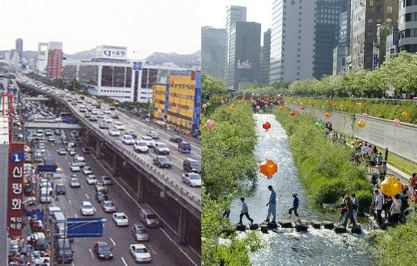
What would happen if they took out what was considered a vital traffic artery carrying 168,000 cars per day? Lots! Improved travel time, improved environment, increased property values, more public space, revitalized central business district.

 Kamala Rao, MCIP, Transportation Planner in Vancouver, BC, and a Sightline board member, profiles Seoul’s success story of urban highway removal at Sightline Daily.

Photo from http://www.preservenet.com/freeways/Seoul_BeforeDongdaemunArea.jpg and http://www.vector1media.com/spatialsustain/koreas-urban-sensor-web-test-projects.html

More Cities are Razing Urban Highways

Removal of aging highways is a strategy some cities are using to try and boost their downtown districts http://www.csmonitor.com/USA/2011/0302/Downtown-need-a-makeover-More-cities-are-razing-urban-highways – Christian Science Monitor

By Jeremy Kutner, Correspondent / March 2, 2011
New Haven, Conn. In New Haven, Conn., a mistake of the past – one that displaced hundreds, razed a neighborhood, and physically divided a city – is finally set to be rectified: A highway is going to be demolished.

Some people in New Haven have been waiting to see this for 40 years, ever since it became clear that a modern roadway slicing through the heart of downtown would not bring the hoped-for suburban shoppers and revitalization. That waiting list is long, it turns out, as cities across the United States look to erase some of the damage from urban highway construction of the 1950s and ’60s – tearing up or replacing the roadways and attempting to restitch bulldozed neighborhoods. ….

In Providence, Rhode Island transportation officials opted to reroute a dilapidated section of highway, moving the road Some people in New Haven have been waiting to see this for 40 years, ever since it became clear that a modern roadway slicing through the heart of downtown would not bring the hoped-for suburban shoppers and revitalization. That waiting list is long, it turns out, as cities across the United States look to erase some of the damage from urban highway construction of the 1950s and ’60s – tearing up or replacing the roadways and attempting to restitch bulldozed neighborhoods.outside the downtown core at no small expense. Demolition began late last year.

Now, “there’s an opportunity not only to create a new neighborhood but to sort of reinvent our downtown,” says Robert Azar, a planner with the Providence Department of Planning and Development….”

Less Congestion, More Sprawl

More on the irrationality of current traffic congestion measures, from Gateway Streets, a St. Louis blog:

Work continues on 141 between Olive and 364. Credit: modot_stl_photos.

“… a closer look at the data in the Urban Mobility Report reveals a puzzling fact: despite reduced congestion on the region’s roads, commutes in St. Louis are getting longer than ever before. Peak hour commuters spent an average of 289 hours behind the wheel in 2009, 36 hours more than in 1999 when congestion was significantly worse. In fact, according to the UMR report, St. Louis has the 5th longest commutes among metro areas over 1 million population (Los Angeles and New York, bafflingly, are ranked 22nd and 33rd, respectively). How is it that that commuting times get longer as congestion decreases?

The answer to the puzzle, of course, lies in the sprawling nature of St. Louis’s suburbs. Between 1950 and 2000, St. Louis’s urban population grew 48% while urban land area grew over 260%.

St. Louis’s extensive highway network may be partially to blame for the region’s sprawl. As pointed out by the Urbanophile, St. Louis has the 3rd most freeway lane miles per capita amongst metro areas over 1 million in population ….”

Driven Apart

As The I-81 Challenge –  official decision-making process led by two entities, the New York State Department of Transportation and the Syracuse Metropolitan Transportation Council (SMTC), the region’s metropolitan planning organization (MPO) – gets into gear, the Rethinking I-81 blog will reopen for comments.   

Driven Apart: How sprawl is lengthening our commutes and why misleading mobility measures are making things worse – “A new report from CEOs for Cities unveils the real reason Americans spend so much time in traffic and offers a dramatic critique of the 25 year old industry standard … often used to justify billions of dollars in expenditures to build new roads and highways.

“The report recommends a new system for measuring urban transportation performance that includes emphasizing accessibility and focusing on measures of land uses, trip lengths and mode choices as well as travel speeds”.


“Rethinking I-81”: OCL’s Study Blog

Stent (or Dagger?) in the Heart of Town: Urban Freeways in Syracuse, 1944-1967

The 1961 Decisions in Syracuse, by SU political scientists Guthrie Birkhead, Roscoe Martin, and others, explored a series of case studies of metropolitan action in Syracuse in the Post–World War II era. The study focused on public decision-making and the relative influence of various interest groups in the power structure at a time of emerging demographic change and suburbanization.  The case studies are fascinating glimpses at how important metropolitan issues, from sewage treatment and water district  to government reorganization and real estate development were approached in a regional context.

Although it occurred in the same time period, the I-81 construction was not a subject of the book. Creation of the highway system in and around Syracuse was much less a local, or metropolitan, process than a process in which federal and state plans, and dollars, determined transportation developments.  The recent study, Stent (or Dagger?) in the Heart of Town: Urban Freeways in Syracuse, 1944-1967, published in the May 2009 issue of the Journal of Planning History, takes a look at decision-making on the urban freeways in Syracuse.

Author Joseph F. C. Di Mento, a professor of Law and of Planning Policy and Design at the University of California Irvine, concludes that the timing of transportation decisions in Syracuse was important.  Before the evolution of environmental law, and at a time when the urban renewal goals of “slum clearance” and redevelopment converged with the funding opportunities of the federal highway fund, the fiscally conservative city administration deferred to state highway plans.  A relatively weak city planning function and a “strong engineering-driven state highway bureaucracy and gubernatorial positions” influencing choices Syracuse made, “ …led to an outcome different from what city fathers and officials had envisioned…”.

The approaching need to reconstruct parts of the freeway through the city gives Syracuse an opportunity to develop a new vision for the community.

“Rethinking I-81” – OCL’s Study Blog

Building Infrastructure-Building Experience

This week’s Citiwire.net columns by Neal Peirce and Alex Marshall focus on the promise of high speed rail as the “New Deal” for transportation.  “My high-speed rail proposal,” President Obama is quoted as saying, “will lead to innovations that change the way we travel in America. We must start developing clean, energy-efficient transportation that will define our regions for centuries to come.”

Certainly, the costs of the projects will be challenging, but more than that, “America’s become tortuously slow, way behind world standards, in building any kind of infrastructure,” according to Peirce. “Some states spend years just adding HOV or exclusive bus lanes to existing highways.”

Marshall reports that former Massachusetts governor Michael Dukakis, a big rail booster, says that over-budget, drawn-out infrastructure construction has become the norm.  State and local governments tolerate huge multi-year delays.  “The cure, says Dukakis is competence: to learn to undertake great projects again, and to value quality government.”

The I-81 corridor project, whatever form it takes, will be of a scale not experienced in Syracuse since the viaducts were originally planned and constructed.  Our elected officials and transportation authorities will have to exhibit the scale of leadership and guidance that a project of its magnitude requires.

“Rethinking I-81”: OCL’s Study Blog

WHAT WOULD HAPPEN IF I-81 DOWNTOWN CLOSED?

When we think about engineering solutions to traffic problems, it’s useful to keep in mind that human behavior is a key variable in the equation.  Drivers adjust their behavior to the situations presented to them.  When the 1989 Loma Prieta earthquake damaged San Francisco’s Central Freeway, the destroyed northern portion of the viaduct was demolished, while the southern portion, running above Octavia Street, remained.   A city task force recommended replacing the elevated freeway with a surface boulevard that would make it easier for local traffic to access the neighborhood, but the state department of transportation decided to rebuild the deck.  When the reconstruction project began, the predicted gridlock failed to materialize; local streets handled the traffic without any major problems. With this evidence that the street grid could handle most of the traffic when the freeway was shut down, neighborhood residents ultimately were able to force a referendum that ended in removal of most of the freeway and the creation of Octavia Boulevard.

What would happen if sections of Interstate 81 through Syracuse were shut down for an extended period?  We actually have some experiences that give us an indication of how Central New Yorkers would react to a planned closure of a main route to downtown and the University Hill area.  Ten years ago, construction closed the northbound lanes of I-81 from the Brighton Avenue exit to the Harrison Street on-ramp for about three months.  When that project was complete, the southbound lanes were closed from Interstate 690 to Calthrop Avenue.  It was the first major closure since I-81 north was shut down for eight months in 1988 to repair badly deteriorated bridge decks.

For months before the shutdown, the State Department of Transportation conducted a massive campaign to inform city officials, businesses, and residents about the project and alternative routes.  The newspapers were full of warnings for weeks in advance of the construction for the estimated 30,000 drivers a day who took I-81 north through Syracuse.  In addition, plans including street sign and traffic signal changes, additional traffic police, and even a free OnTrack train between Jamesville and Armory Square were put in place to keep traffic moving.

 “Where’s the Rush?  First Day of I-81 Detour Goes Smoothly” was the headline on the May 27, 1999 Post-Standard story.    At the peak of the first rush hour affected by the northbound shutdown, “…there was virtually no traffic on the detour route where state transportation officials feared a major backup.”  Commuters found their own quickest secondary routes to use, diverting cars from the detour routes and allowing traffic to flow smoothly.

Commuters leaving downtown during the afternoon rush hour had a more difficult time after DOT shut down the I-81 connector to I-690, and the Harrison Street on-ramp was reduced to one lane.  As drivers avoided the on-ramp and learned to use alternate routes to access I-690 east, traffic eased over the following days, though backups at intersections still occurred, as drivers, particularly those heading north, headed to the Harrison Street ramp.  Deck repairs north of downtown closed lanes and slowed traffic in that area, but even those slowdowns added less than five minutes to total commute time, the DOT spokesman was quoted as saying.

The OnTrack commuter train, which offered free rides between Jamesville and Armory Square during the construction, averaged only 35 riders a day, because, it was assumed, the gridlock that was expected to cause severe traffic delays never occurred.  “Motorists and police feared gridlock would seize the city when a 2 ½ mile stretch of I-81 northbound lanes were closed in May for repairs.  But the back-ups were minor.” (The Post-Standard, August 19, 1999 pg. A1).

When DOT closed down I-81 south, including the connectors from I-690 east and west, affecting nearly 35,000 daily travelers, DOT officials were more optimistic.  In fact, the closure of I-81 south to replace expansion joints and make other repairs, generated almost no news, and apparently only minor traffic tie-ups.  Commuters seemingly adjusted their schedules or their routes through the 2 ½ months of repairs. As then assistant DOT regional director George Angeloro said during the northbound shutdown: “Traffic is like water. It seeks its own levels.”  

A temporary shutdown can give us a partial indication of what might happen if the highway were replaced with an alternative roadway.  As in other cities that have permanently eliminated a freeway, improvements to the surrounding street grid, as well as pedestrian, bicycle, and transit considerations, would be part of the mobility plan. 
Rethinking I-81: OCL’s Study Blog

SHIFTING PRIORITIES: HOW FREEWAY REMOVAL DECISIONS ARE MADE

As we saw in San Francisco’s ‘Freeway Revolt’, the city’s quality of life  and economic development priorities fired opposition to freeways and influenced decisions to reject the building of expressways through the city in the 1950’s and 60’s and their rebuilding in the 1990’s.    But citizen opposition alone is not the only influence on local transportation planning decisions. A recent examination of three cases of freeway removal in the U.S. suggests that four conditions must be met to create an environment where change will take place.

 “Shifting Urban Priorities?  Removal of Inner City Freeways in the United Statesin the 2008 issue of Transportation Research Record: Journal of the Transportation Research Board,  presents an analysis of three cases in which freeway removal was a seriously considered option – San Francisco and Milwaukee, where freeways were removed, and Washington, D.C., where the Whitehurst Freeway, which did not generate strong community support for removal, was rehabilitated.  The authors, Francesca Napolitan of Nelson/Nygaard Associates and P. Christopher Zegras of MIT, note that many of the interstate highways built after passage of the Federal-Aid Highway Act in 1956 are reaching, or have reached, the end of their useful life.  Today, the need for large public investment in rebuilding of the aging infrastructure is juxtaposed with movements toward the need for more sustainable transportation, as well as concerns about urban quality of life. 

 What are the conditions that seem to be requisite for a freeway removal decision?  The authors’ analysis concluded that first, the freeway must be considered unsafe (as in post-earthquake Central Freeway in San Francisco or aging and deteriorating Park East Freeway in Milwaukee).  Secondly, there is often some event that brings the removal alternative to the forefront, or creates a ‘window of opportunity’. The window could be the rise of a champion, such as the election of Mayor Norquist in Milwaukee, or the advancement of the idea by a successful test such as the temporary shutdown of the Central Freeway for repair, which failed to present any major traffic problems. The third consideration at play is that mobility (of vehicles) is a lower priority than other community goals such as quality of life or economic development.  In San Francisco, the residents valued quality of life over high-speed access; in Milwaukee the economic development potential of the re-knit downtown and waterfront was the higher priority than vehicle mobility. Lastly, the writers theorize that the highway removal must have a champion who is an “empowered agent of change”. That is, the “other than mobility” value must be rooted in the power of an individual, such as an influential elected official, or in a group, such as voters in the case of a referendum, or an influential neighborhood grassroots organization.

Washington D.C.’s Whitehurst Freeway was the only one of the cases studied where the decision was made to retain the existing freeway.  Several factors specific to that roadway, the surrounding neighborhood, and the political jurisdiction contributed to the decision to rehabilitate.  But the authors also note that the decision-makers and residents in that situation, which played out in the 1980’s, did not have the benefit of studying a recent, high profile precedent like  San Francisco’s Embarcadero, which had been destroyed by the 1989 earthquake and demolished two years later. 

While no two highways are alike, the authors suggest a new framework for evaluating freeway projects that recognizes a paradigm shift away from pure engineering efficiency to include other community priorities:  along with the standard “fix-it first” and rebuild options, it may be time to include a “tear-down” option when deciding what to do with aging infrastructure.


A working paper version of the published journal article can be found at: http://web.mit.edu/czegras/www/Napolitan_Zegras_FreewayRemoval_Final.pdf